https://gallica.bnf.fr/ark:/12148/bpt6k1261881t
No 75. — Arrangement conclu entre S. M. le roi du Cambodge el le Con-tre-Amiral Gouverneur el Commandant, en chef en Cochinchine, déterminant définitivement la frontière entre le royaume du Cambodge et la Cochinchine française.
S. M. Prêa Bat Somdhch Preà NÔrôdftm Bàrôui Réarn Té Véa Tanâ Préa Chiiu Crùng Càm Pu-chéa Thip Phdey, roi du Cam-bodge,
Et M. le Contre-Amiral Du pré (Marie-Jules), Gouverneur el Commandant en chef en Coehinchine, agissant au nom du Gou-vernement français;
Désirant déterminer définitivement et d'un commun accord, la frontière entre le royaume de Cambodge et la Cochinchine fran-çaise; après avoir fait procéder a l'étude du pays, afin d'appuyer celle ligne de démarcation sur des cours d'eau ou des accidents de terrain suffisamment solides et accuses pour prévenir toute contestation ultérieure, ont adopte et signé la présente conven-tion comportant les dispositions suivantes :
La frontière entre la Cochinchine française et le royaume du Cambodge sera marquée par des poteaux numérotés et portant une inscription indiquant leur objet. Le nombre de poteaux sera de 124, Le numéro 1 sera placé à l'extrémité Est de la frontière et la graduation sera continuée vers l'Ouest dans l'ordre naturel des chiffres, jusqu'au poteau 121, placé a -1,200 mètres environ au nord du canal de Vinh-te l'l du village annamite Hoa-thanh.
Celte frontière passera par les points principaux suivants :
Le point de départ est le poteau numéro I planté sur le bord de la petite rivière de Tonly-lru ; la direction générale de la frontière est ensuite le Sud-ouest et passe par les villages de Sroc-IÙIH, Srôc-paplân, Srôc-han-chrung, Rùng-khriôch, Srôc- cranh, Srôc-chung-ngon, Phum-andet, Srôc-câe, Srôc-cômpông- méan-chey (ou fiengo), suit la rive droite du Cai-bae, remonte par la rive gauche du Caï-cay, passe it Phum-cornpông-casang, Srùc-ta-mcng, Srôc-ta-hong, SrÔe-ehée, Phum-batlm, SrÔc-mav, Srôc-rach-chanh, Srôc-tanm suit la rive nord de l'arroyo de Chris-asey (en annamite Xung-nguyén) ; coupe cet arroyo a t'cm- houchut'c du Peam-sdey (en annamite Ta-du); suit la rive sep- tentriona'c du Rach-banam, traverse le grand neuve à la hauteur de Vinii-c'iuong, passe a Rac-nani, coupe le neuve postérieur au
sud de File de Co-ki (en annamite Cu-Iao-cai-scu); passe 11 l'in- tersection du Prec-croch avec le Préc-slèt; suit une ligne parallèle il l'arroyo de Yinh-tè, Ili ÎXord; aboutit au village de Giang- thanh, et de !a se dirige droit sur Malien, en laissant a l'Est
l'arroyo de Prèc-cros.
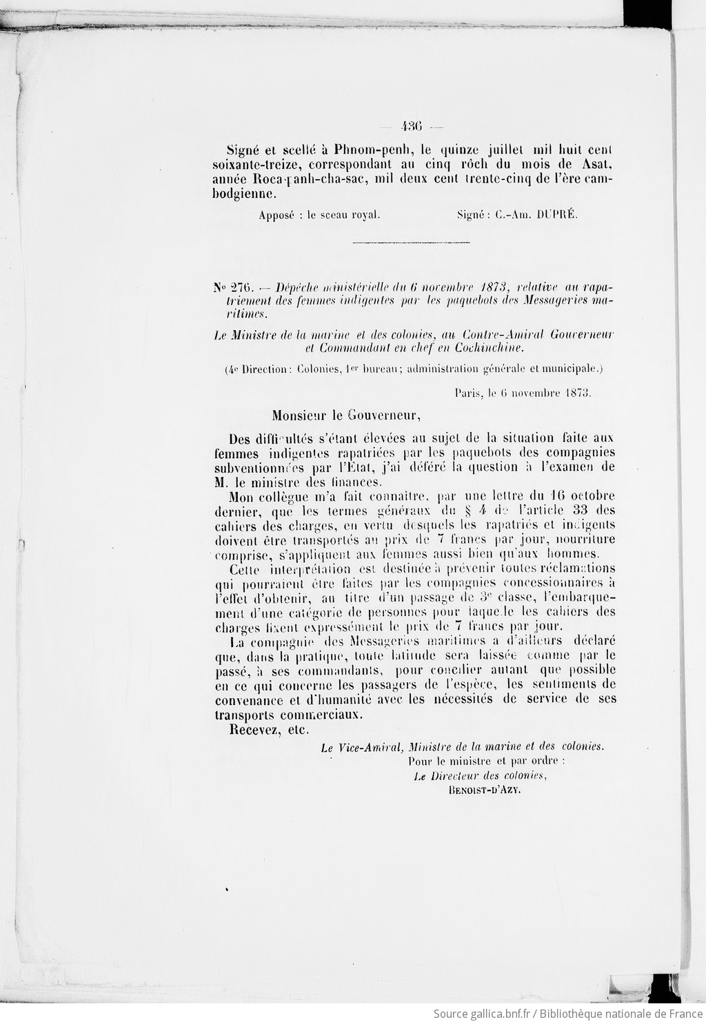
Signé et scellé à Phnom-penh, le quinze juillet mil huit cent soixante-treize, correspondant an cinq rÔch du mois de Asat, année ltoe,,i.[ anh-cha-sac, mil deux cent trente-cinq de l'ère cam- bodgienne.
Apposé : le sceau royal. Signé: C.-Am. DUPRE.
Agreement concluded Between His Majesty the King of Cambodia and the Rear Admiral, Governor and Commander-in-Chief in Cochin China, to Determine definitively the boundary Between the Kingdom of Cambodia and French Cochin China.
H.M. Prea Bat Som Dach Prea Norodom Baroui Ream Te Vea Tans Pres-Chau Crung Cam Pu Chea Thip Phdey, King of Cambodia, and the Rear Admiral Dupre (Marie - Jules), Governor and Commander-in-Chief in Cochin China acting in the name of the French Government.
Wishing to determine by joint agreement the boundary between the Kingdom of Cambodia and French Cochin China, and after having studied the country to place this line of demarcation on waterways or hilly terrain sufficiently reliable and prominent enough to avoid any later dispute, have adopted and signed the present agreement which includes the following provisions:
The border between French Cochin China and the Kingdom of Cambodia will be marked by numbered pillars, bearing an inscription indicating their purpose. The number of posts will be 124. Number one will be placed at the eastern end of the border and the numbers will increase toward the west to Pillar 124, placed about 1,200 meters north of the Vinh-Te canal and of the Annamite Village of Hoa-Thanh.
This border line will pass by the following main points:
The starting point is post No. 1 installed on the bank of the stream of Tonly-Tru; the general direction of the border will then be southwest and will pass by the villages of Sroc-Tun, Sroc- Paplan, Sroc-Ban Chrung, Rung-Khoch, Sroc-Tranh, Sroc-Chung-Ngon, Phum-Andet, Sroc- Cao, Sroc-Com-Pong-Mean-Chey (or Bango); will follow the right bank of the Cai-Bac, ascend by the left bank of the Cai-Cay, pass through Phum-Com-Pong-Casang, Sroc-Ta-Meng, Sroc- Ta-Trong, Sroc Cheo, Phum-Bathu, Sroc-Rach-Chanh, Sroc-Tanu; then it will follow the north bank of the canal of Chris-Asey (in Annamite Xung-Nguyen); it will cut this canal at the mouth of the Peam-Sdey (in Annamite Ta-Su); it will follow the northern bank of the Rach-Banam, cross the main river at the latitude of Vinh-Chuong, pass through Bac-Nam, cut the river south of the island of Co-Ki (in Annamite Cu-Lao Cai-Sen); it will pass through the intersection of the Prec- Croch with the Prec-Slot; it will follow a line parallel to the canal of Vinh-Te, to the north; it will end at the village of Giang-Thanh and will be drawn from there directly to Ha-Tien, with the canal of Prec-Cros to the east.
Signed and sealed in Phnom-Penh on 15 July 1873, corresponding to the Fifth Roch of the month of Asat, Roca-Panh-Cha-Sac year, 1235 of the Cambodia era.
The royal seal.
Signed: Real Admiral DUPRE
Bulletin Officiel de la Cochinchine francaise, Annee 1873 No. 12, p. 435.
Thỏa ước về việc xác định dứt điểm đường biên giới giữa Vương quốc Campuchia và xứ Nam kỳ thuộc Pháp 1873
Ký ngày 15-7-1873
Ngài Préa Bat Som Dâch Prea Norodom Baroui Réam Té Yéa Tânâ Préa Chau Crung Campuchia Thip Phdey, vua Campuchia,
Và ông Phó Đô đốc Hải quân Dupré (Marie - Jules), Thống đốc và Tổng tư lệnh xứ Nam Kỳ, thay mặt Chính phủ Pháp;
Mong muốn xác định dứt điểm, qua thỏa thuận, đường biên giới giữa vương quốc Campuchia và xứ Nam Kỳ thuộc Pháp, sau khi đã cho tiến hành nghiên cứu địa hình khu vực để có cơ sở xác định đường phân giới theo các dòng chảy hoặc các chỗ lồi lõm đủ bền vững và rõ ràng nhằm tránh mọi tranh cãi về sau, đã thông qua và ký vào Thỏa ước này, gồm các điều khoản sau:
Biên giới giữa xứ Nam Kỳ thuộc Pháp và vương quốc Campuchia sẽ được đánh dấu bằng các cột mốc có đánh số, có ghi chú nêu công dụng của cột. Tổng số cột mốc là 124. Cột mốc số 1 sẽ được đặt ở điểm cực đông của đường biên giới và các cột tiếp theo sẽ tiến dần về hướng tây, theo trật tự tự nhiên của các con số, cho đến cột số 124, đặt cách kênh Vĩnh Tế và làng Hoa Thanh của xứ An Nam 1.200 mét về phía bắc.
Đường biên giới này sẽ đi qua những điểm chính sau:
Điểm bắt đầu là cột mốc số 1 đặt trên bờ con sông nhỏ Tonlé Tru; hướng chung của đường biên giới là đi về hướng tây nam và đi ngang qua các làng Sroc Tun, Sroc Papan, Sroc Banchrung, Rung Knoch, Sroc Tranh, Sroc Chung Ngon, Phumandet, Sroc Câe, Sroc Kompong Menchey (hay Bengo), đi theo bờ Cái Bắc, ngược tả ngạn của sông Cái Cây, đi qua Phum Kompong Cassang; Sroc Tameng, Sroc Tahong, Sroc Chéo, Phum Bathu, Sroc May, Sroc Rach Chanh, Sroc Tanu, đi theo bờ Bắc rạch Chris Asey (tên An Nam là Ta Du); đi theo bờ Bắc ranh Banan, cắt sông Hậu ở phía Nam đảo Co Ki (tên An Nam là cù lao Cái Sen); đi qua giao điểm của Prèk Croch và Prèk Slot; rồi theo đường song song với kênh Vĩnh Tế ở phía Bắc, đến làng Giang Thành và từ đó đi thẳng tới Hà Tiên để kênh Prèk Croch về phía Đông.
Được ký và đóng dấu tại Phnôm Pênh, ngày 15 tháng 7 năm 1873, tương ứng với ngày 5 (rôch), tháng Asat, năm Roca Panhcha Sac, 1235 theo lịch Campuchia.
Đã đóng dấu: Con dấu Vương quốc | Đã ký: Phó Đô đốc Hải quân DUPRÉ
Nguồn http://travinh.gov.vn/wps/portal/tuyengiao/!ut/p/c0/04_SB8K8xLLM9MSSzPy8xBz9CP0os3gDIws_QzcPIwOLMAMLA8fA4GDfEPdAA6MQM_2CbEdFAONX-q0!/?WCM_GLOBAL_CONTEXT=/wps/wcm/connect/bantuyengiao/ban+tuyen+giao/lich+su+dang/luoc+su+vung+dat+nam+
https://gallica.bnf.fr/ark:/12148/bpt6k1261881t/f3.jpeg
https://gallica.bnf.fr/ark:/12148/bpt6k1261881t/f4.jpeg
https://gallica.bnf.fr/ark:/12148/bpt6k1261881t
# No 75. — Arrangement conclu entre S. M. le roi du Cambodge el le Con-tre-Amiral Gouverneur el Commandant, en chef en Cochinchine, déterminant définitivement la frontière entre le royaume du Cambodge et la Cochinchine française.
S. M. Prêa Bat Somdhch Preà NÔrôdftm Bàrôui Réarn Té Véa Tanâ Préa Chiiu Crùng Càm Pu-chéa Thip Phdey, roi du Cam-bodge,
Et M. le Contre-Amiral Du pré (Marie-Jules), Gouverneur el Commandant en chef en Coehinchine, agissant au nom du Gou-vernement français;
Désirant déterminer définitivement et d'un commun accord, la frontière entre le royaume de Cambodge et la Cochinchine fran-çaise; après avoir fait procéder a l'étude du pays, afin d'appuyer celle ligne de démarcation sur des cours d'eau ou des accidents de terrain suffisamment solides et accuses pour prévenir toute contestation ultérieure, ont adopte et signé la présente conven-tion comportant les dispositions suivantes :
La frontière entre la Cochinchine française et le royaume du Cambodge sera marquée par des poteaux numérotés et portant une inscription indiquant leur objet. Le nombre de poteaux sera de 124, Le numéro 1 sera placé à l'extrémité Est de la frontière et la graduation sera continuée vers l'Ouest dans l'ordre naturel des chiffres, jusqu'au poteau 121, placé a -1,200 mètres environ au nord du canal de Vinh-te l'l du village annamite Hoa-thanh.
Celte frontière passera par les points principaux suivants :
Le point de départ est le poteau numéro I planté sur le bord de la petite rivière de Tonly-lru ; la direction générale de la frontière est ensuite le Sud-ouest et passe par les villages de Sroc-IÙIH, Srôc-paplân, Srôc-han-chrung, Rùng-khriôch, Srôc- cranh, Srôc-chung-ngon, Phum-andet, Srôc-câe, Srôc-cômpông- méan-chey (ou fiengo), suit la rive droite du Cai-bae, remonte par la rive gauche du Caï-cay, passe it Phum-cornpông-casang, Srùc-ta-mcng, Srôc-ta-hong, SrÔe-ehée, Phum-batlm, SrÔc-mav, Srôc-rach-chanh, Srôc-tanm suit la rive nord de l'arroyo de Chris-asey (en annamite Xung-nguyén) ; coupe cet arroyo a t'cm- houchut'c du Peam-sdey (en annamite Ta-du); suit la rive sep- tentriona'c du Rach-banam, traverse le grand neuve à la hauteur de Vinii-c'iuong, passe a Rac-nani, coupe le neuve postérieur au
sud de File de Co-ki (en annamite Cu-Iao-cai-scu); passe 11 l'in- tersection du Prec-croch avec le Préc-slèt; suit une ligne parallèle il l'arroyo de Yinh-tè, Ili ÎXord; aboutit au village de Giang- thanh, et de !a se dirige droit sur Malien, en laissant a l'Est
l'arroyo de Prèc-cros.
Signé et scellé à Phnom-penh, le quinze juillet mil huit cent soixante-treize, correspondant an cinq rÔch du mois de Asat, année ltoe,,i.[ anh-cha-sac, mil deux cent trente-cinq de l'ère cam- bodgienne.
Apposé : le sceau royal. Signé: C.-Am. DUPRE.
---
# Agreement concluded Between His Majesty the King of Cambodia and the Rear Admiral, Governor and Commander-in-Chief in Cochin China, to Determine definitively the boundary Between the Kingdom of Cambodia and French Cochin China.
H.M. Prea Bat Som Dach Prea Norodom Baroui Ream Te Vea Tans Pres-Chau Crung Cam Pu Chea Thip Phdey, King of Cambodia, and the Rear Admiral Dupre (Marie - Jules), Governor and Commander-in-Chief in Cochin China acting in the name of the French Government.
Wishing to determine by joint agreement the boundary between the Kingdom of Cambodia and French Cochin China, and after having studied the country to place this line of demarcation on waterways or hilly terrain sufficiently reliable and prominent enough to avoid any later dispute, have adopted and signed the present agreement which includes the following provisions:
The border between French Cochin China and the Kingdom of Cambodia will be marked by numbered pillars, bearing an inscription indicating their purpose. The number of posts will be 124. Number one will be placed at the eastern end of the border and the numbers will increase toward the west to Pillar 124, placed about 1,200 meters north of the Vinh-Te canal and of the Annamite Village of Hoa-Thanh.
This border line will pass by the following main points:
The starting point is post No. 1 installed on the bank of the stream of Tonly-Tru; the general direction of the border will then be southwest and will pass by the villages of Sroc-Tun, Sroc- Paplan, Sroc-Ban Chrung, Rung-Khoch, Sroc-Tranh, Sroc-Chung-Ngon, Phum-Andet, Sroc- Cao, Sroc-Com-Pong-Mean-Chey (or Bango); will follow the right bank of the Cai-Bac, ascend by the left bank of the Cai-Cay, pass through Phum-Com-Pong-Casang, Sroc-Ta-Meng, Sroc- Ta-Trong, Sroc Cheo, Phum-Bathu, Sroc-Rach-Chanh, Sroc-Tanu; then it will follow the north bank of the canal of Chris-Asey (in Annamite Xung-Nguyen); it will cut this canal at the mouth of the Peam-Sdey (in Annamite Ta-Su); it will follow the northern bank of the Rach-Banam, cross the main river at the latitude of Vinh-Chuong, pass through Bac-Nam, cut the river south of the island of Co-Ki (in Annamite Cu-Lao Cai-Sen); it will pass through the intersection of the Prec- Croch with the Prec-Slot; it will follow a line parallel to the canal of Vinh-Te, to the north; it will end at the village of Giang-Thanh and will be drawn from there directly to Ha-Tien, with the canal of Prec-Cros to the east.
Signed and sealed in Phnom-Penh on 15 July 1873, corresponding to the Fifth Roch of the month of Asat, Roca-Panh-Cha-Sac year, 1235 of the Cambodia era.
The royal seal.
Signed: Real Admiral DUPRE
Bulletin Officiel de la Cochinchine francaise, Annee 1873 No. 12, p. 435.
---
# Thỏa ước về việc xác định dứt điểm đường biên giới giữa Vương quốc Campuchia và xứ Nam kỳ thuộc Pháp 1873
Ký ngày 15-7-1873
Ngài Préa Bat Som Dâch Prea Norodom Baroui Réam Té Yéa Tânâ Préa Chau Crung Campuchia Thip Phdey, vua Campuchia,
Và ông Phó Đô đốc Hải quân Dupré (Marie - Jules), Thống đốc và Tổng tư lệnh xứ Nam Kỳ, thay mặt Chính phủ Pháp;
Mong muốn xác định dứt điểm, qua thỏa thuận, đường biên giới giữa vương quốc Campuchia và xứ Nam Kỳ thuộc Pháp, sau khi đã cho tiến hành nghiên cứu địa hình khu vực để có cơ sở xác định đường phân giới theo các dòng chảy hoặc các chỗ lồi lõm đủ bền vững và rõ ràng nhằm tránh mọi tranh cãi về sau, đã thông qua và ký vào Thỏa ước này, gồm các điều khoản sau:
Biên giới giữa xứ Nam Kỳ thuộc Pháp và vương quốc Campuchia sẽ được đánh dấu bằng các cột mốc có đánh số, có ghi chú nêu công dụng của cột. Tổng số cột mốc là 124. Cột mốc số 1 sẽ được đặt ở điểm cực đông của đường biên giới và các cột tiếp theo sẽ tiến dần về hướng tây, theo trật tự tự nhiên của các con số, cho đến cột số 124, đặt cách kênh Vĩnh Tế và làng Hoa Thanh của xứ An Nam 1.200 mét về phía bắc.
Đường biên giới này sẽ đi qua những điểm chính sau:
Điểm bắt đầu là cột mốc số 1 đặt trên bờ con sông nhỏ Tonlé Tru; hướng chung của đường biên giới là đi về hướng tây nam và đi ngang qua các làng Sroc Tun, Sroc Papan, Sroc Banchrung, Rung Knoch, Sroc Tranh, Sroc Chung Ngon, Phumandet, Sroc Câe, Sroc Kompong Menchey (hay Bengo), đi theo bờ Cái Bắc, ngược tả ngạn của sông Cái Cây, đi qua Phum Kompong Cassang; Sroc Tameng, Sroc Tahong, Sroc Chéo, Phum Bathu, Sroc May, Sroc Rach Chanh, Sroc Tanu, đi theo bờ Bắc rạch Chris Asey (tên An Nam là Ta Du); đi theo bờ Bắc ranh Banan, cắt sông Hậu ở phía Nam đảo Co Ki (tên An Nam là cù lao Cái Sen); đi qua giao điểm của Prèk Croch và Prèk Slot; rồi theo đường song song với kênh Vĩnh Tế ở phía Bắc, đến làng Giang Thành và từ đó đi thẳng tới Hà Tiên để kênh Prèk Croch về phía Đông.
Được ký và đóng dấu tại Phnôm Pênh, ngày 15 tháng 7 năm 1873, tương ứng với ngày 5 (rôch), tháng Asat, năm Roca Panhcha Sac, 1235 theo lịch Campuchia.
Đã đóng dấu: Con dấu Vương quốc | Đã ký: Phó Đô đốc Hải quân DUPRÉ
Nguồn http://travinh.gov.vn/wps/portal/tuyengiao/!ut/p/c0/04_SB8K8xLLM9MSSzPy8xBz9CP0os3gDIws_QzcPIwOLMAMLA8fA4GDfEPdAA6MQM_2CbEdFAONX-q0!/?WCM_GLOBAL_CONTEXT=/wps/wcm/connect/bantuyengiao/ban+tuyen+giao/lich+su+dang/luoc+su+vung+dat+nam+


